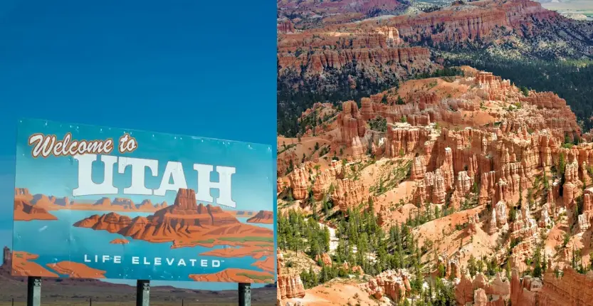
There are plenty of wonderful sites and great locations in Utah, but we have the inside scoop on the wonders and the ideal time to visit them. Although Utah’s scenery is always stunning, if you want to be so calm and in a state of stupor that you cease breathing, timing is crucial.
It shares the Four Corners region with Arizona, Colorado, and New Mexico, making it one of the Mountain States. In addition, it shares boundaries with Nevada to the west, Idaho to the north, and Wyoming to the northeast.
Let’s concentrate on Utah’s most amazing locations.
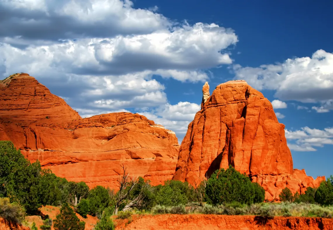
Bryce Canyon
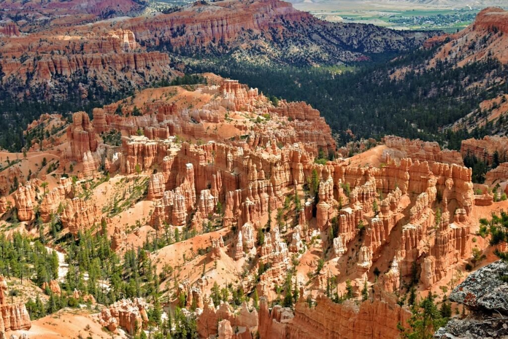
Bryce Canyon is not a single canyon, but a series of natural amphitheaters or bowls, carved into the edge of a high plateau. The most famous of these is the Bryce Amphitheater, which is filled with irregularly eroded spires of rocks called hoodoos. Perhaps every visitor to the park will spend at least some time marvelling at its four main viewpoints, all found within the first few miles of the park: Bryce Point, Inspiration Point, Sunset Point, and Sunrise Point. Between April and October a shuttle service is operated in this area of the park to reduce congestion.
Other viewpoints are found all along the park’s 18-mile main road which travels from the park’s only entrance in the north along the plateau rim to its highest elevations in the south (over 9,000 ft). Hiking trails explore the forests of the plateau, connect between viewpoints along the rim of the Bryce Amphitheater, and wander through the hoodoos below.
Bryce Canyon offers two campground sites (one in winter) and lodging is available at the Bryce Canyon Lodge during the summer season. During winter, hotel rooms are available in the park at the Sunset Hotel.
Rainbow Bridge National Monument
This spectacular natural sandstone bridge is one of the world’s largest and an iconic symbol of Lake Powell.

Rainbow Bridge National Monument is a breathtaking natural bridge found within Glen Canyon National Recreation Area. The bridge was created by continual erosion by wind, water, and time, eventually sculpting the rock into its current spectacular shape. The formation is one of the world’s largest natural bridges. It measures 290 feet broad and stands 275 feet tall.
Rainbow Bridge was declared as a National Monument by President William Howard Taft in 1910, making it one of the first protected locations in the United States. It is managed by the National Park Service.
Visitors can travel to Rainbow Bridge by boat on Lake Powell. The trek offers breathtaking views of the neighboring red rock canyons and the immense length of the lake. Alternatively, hikers can approach Rainbow Bridge via two trails that begin near Navajo Mountain. Both paths are categorized as strenuous.
Coral Pink Sand Dunes State Park
This part of Utah’s red-rock area is distinguished for its colorful sand dunes.
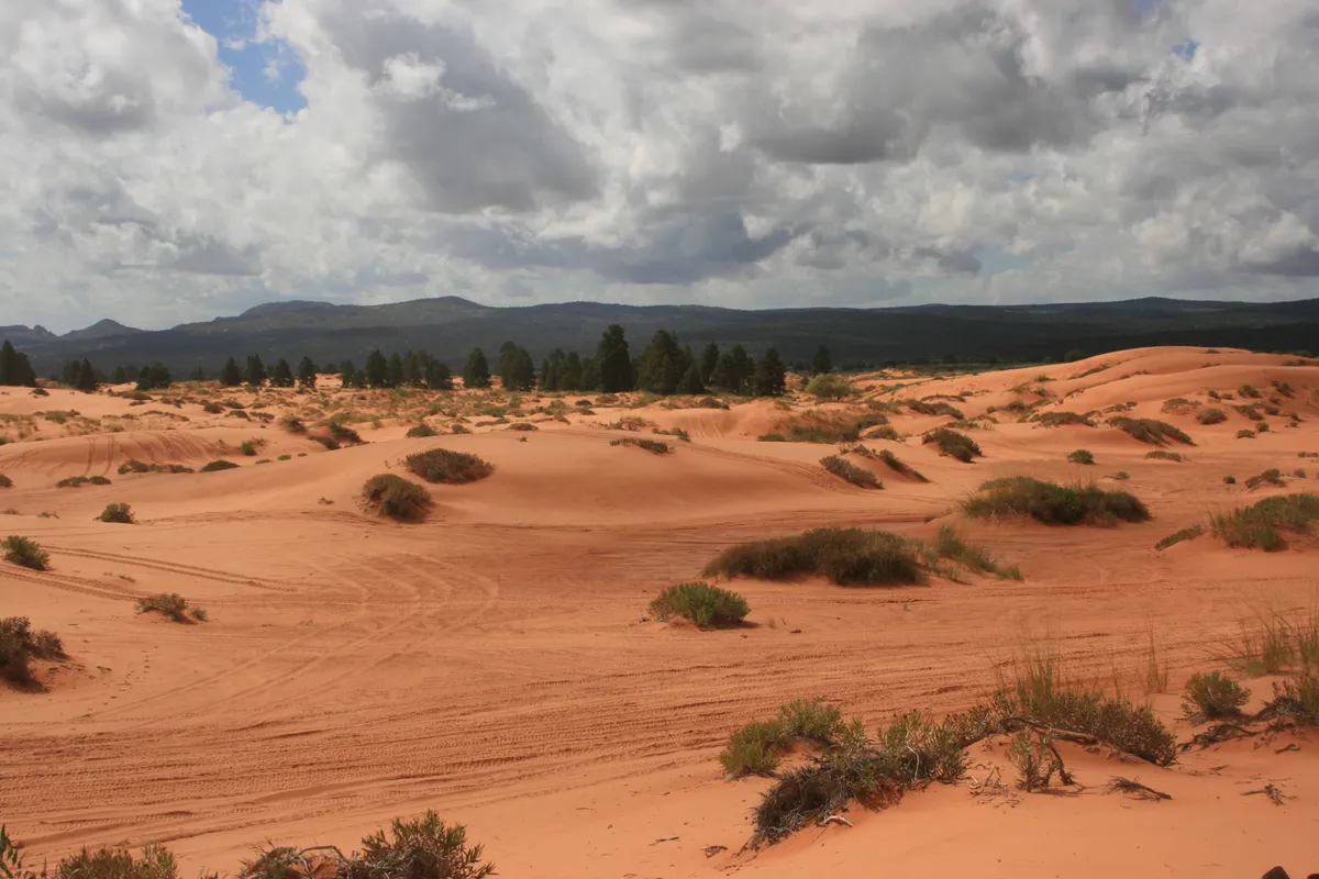
Although overshadowed by the famed national parks nearby, this Utah state park is nonetheless worth a visit. Sand dunes are unique in this section of the Colorado Plateau, and the orange-pink tint of the sand is stunning. The sand is recycled from the erosion of the Navajo Sandstone, and the color comes from iron oxide minerals in the sandstone.
That explains the strange sand, but why was it gathered in a dune field? A breach in the hills to the south directs the predominant southerly wind to where it can mobilize the sand, which is subsequently deposited when the wind expands and slows beyond the opening.
Several creatures unique to the area can be found there. The Coral Pink Sand Dunes Tiger Beetle is only found in the dunes and has been proposed for “endangered” classification due to its vulnerability to motorized activities. However, prohibiting motorized travel in the core of its habitat appears to have stabilized its population.
The dunes are also one of four locations where the endangered Welsh’s milkweed grows. Finally, the Kanab yucca has a range of around 20 miles, focused on the dunes. However, this plant is available as an ornamental for planting, providing an interesting hedge against extinction.
Snow Canyon State Park
Despite having red, orange, and variegated Navajo Sandstone cliffs, this state park is frequently eclipsed by its better famous neighbor.

Snow Canyon State Park is focused on the eponymous canyon, which runs primarily north-south with east and west branches in the park’s northern portion. It’s carved from Navajo Sandstone, which creates beautiful cliffs. They are mostly dark red, but some are lighter and even multicolored. In contrast to Zion, dense black basalt has flowed down the canyon and topped the cliffs, creating a stunning contrast.
One interesting sight is an alcove where early settlers etched their names in axle grease, which has survived over the decades. There is also a short hike to two lava tunnels in the basalt that can be explored with caution. If you want to enter, make sure you have a torch.
The canyon is named for Lorenzo and Erastus Snow, pioneering Utah pioneers. It is part of the Red Cliffs Desert Reserve, which was established to preserve habitat for the desert tortoise and other animals. The park has also served as a famous backdrop for Western films over the years.
Gemini Bridges
It is safe and permitted to stroll across these twin natural sandstone arches.

The area near Moab, Utah is famed for its natural arches, many of which are conserved in Arches National Park. Of course, those arches are carefully protected from human activity, and some of them would undoubtedly suffer harm if crowds were allowed to swarm over them.
Still, walking across a natural stone arch would be enjoyable, and Gemini Bridges provide that opportunity. This pair of sturdy arches is completely safe and lawful to cross on foot. They are located on public land administered by the Bureau of Land Management outside of Moab. They’re also in the center of Moab’s gorgeous red-rock region, so the location is worth a visit just for that.
Cascade Falls
An incredible waterfall cascades down an orange-white cliff face and flows into the Virgin River’s headwaters above Zion National Park.

Southwestern Utah is noted for its stunning beauty, which includes several national parks and monuments. The orange-and-white Claron Formation (formerly known as the Wasatch Formation) is responsible for both Bryce Canyon National Park and Cedar Breaks National Monument. In comparison, the Pink Cliffs produced by the Claron above the Virgin River Rim appear bland. Except for one thing, Cascade Falls.
At one point, water emerges from the Pink Cliffs and falls into the Virgin River’s headwaters, creating a stunning and strange cascade. It emerges at an elevation of around 8,800 feet, while the ridge above reaches over 9,400 feet. The water comes from small Navajo Lake, which has a natural dam made of basalt lava and floods the valley floor beyond that ridge. The lake is a little more than a mile away from Cascade Falls and has an elevation of little more than 9,000 feet. The Claron Formation is porous enough that lake water has found a way through it.
Landscape Arch
The world’s fifth-largest natural arch is also the longest outside of China.

NABS classifies the world’s longest natural rock arches according to their span, which is defined as the horizontal extent of unsupported rock in the arch. And in these rankings, China clearly reigns supreme, with all four of the world’s longest natural arches located within its borders. Then there’s Landscape Arch in Arches National Park, Utah, which NABS considers the world’s fifth-largest natural arch and the longest outside of China.
Landscape Arch is located within Arches National Park, which covers 76,679 acres and is called after the over 2,000 natural sandstone arches that dot its high-desert landscape. In 2004, a team employed laser technology to measure Landscape Arch. They discovered that it had a span of 290.1 feet (plus or minus 0.8 feet), a height of 77.5 feet, a width of 18 feet, a thickness of 6 feet, and an opening width of 295 feet.
Landscape Arch therefore became the largest natural stone arch in the United States. Its potential as a world record breaker, however, was dashed by precise measurements of a few arches in China. The longest of these was Fairy Bridge (Xian Ren Qiao), a natural bridge cut from limestone karst by the Buliu River in Guangxi Province. Since 2010, the Fairy Bridge has been regarded the world’s longest natural arch, measuring around 400 feet across the span of its opening.
Factory Butte
A magnificent, frightening sandstone peak rises over a landscape that is equal parts Mordor and the Moon.
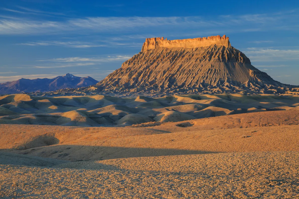
Utah is famous for its magnificent national parks, such as Capitol Reef and Bryce Canyon, but it also has a lot to offer interested visitors willing to venture off the usual path. Factory Butte, a cathedral-like sandstone hill rising over the craggy Caineville badlands, is one of these lesser-known treasures.
Factory Butte, which is part of an ensemble of small, flat-topped mesas known as the Upper Blue Hills, stands 6,302 feet tall. With its root-like combs, crags, and shoulders that snake towards the hilltop, it appears to be deeply embedded in the ground, similar to an old rock stump.
The surrounding, arid scenery is equally surreal; it feels like you’re visiting another planet, which is understandable given that you’re likely to be the only one there.
When visiting this brilliant creation, don’t forget to bring your camera. While the sight is stunning on a cloudy afternoon, it will undoubtedly be much more strange at sunset.
Kodachrome Basin Spires
The odd sedimentary spires in this tranquil park are called after Kodak’s color film.
The southern part of Utah is a veritable feast of natural wonders and geological formations, with five national parks in the region alone. Other, lesser-known parks and reserves in the region, on the other hand, continue to provide opportunities to explore unusual surroundings and retreat into the woods.
One such example is Kodachrome Basin State Park. It is quite easy to get to, but far enough off the main road that many visitors may miss it.
The park’s dozens of distinctive sandstone spires are the highlight of the stunning terrain. Unlike Bryce Canyon’s hoodoos or Capitol Reef’s cliffs, these sedimentary monoliths are isolated slabs of rock left standing as sentinels by the wind.
There are 67 spires scattered around the park, and visitors can walk around and amid them, as well as into the deep gullies formed by millennia of erosion. The hills around the park are steep enough that vegetation cannot adhere to them, revealing the brilliant colors of the sedimentary rock beneath.
The park’s name comes from the intensity and variety of its colors. In 1948, a National Geographic Society expedition requested special permission from the Kodak business to use the name of their film to highlight the park’s splendor.
Hikers can enjoy quiet isolation from the bustling throng while walking along the carefully delineated routes, seeing the intricate interplay of plant life just clinging to the scant soil and sheer rock.
The park’s distant location also allows for camping beneath some of the darkest sky possible. The high altitude, clean desert air, and lack of light pollution combine to provide breathtaking vistas of the night sky. Campers willing to risk a cold desert morning can watch the dawn over the desert plains.
Bonneville Salt Flats / Bonneville Speedway
Come for the speed, leave in love with the desert.
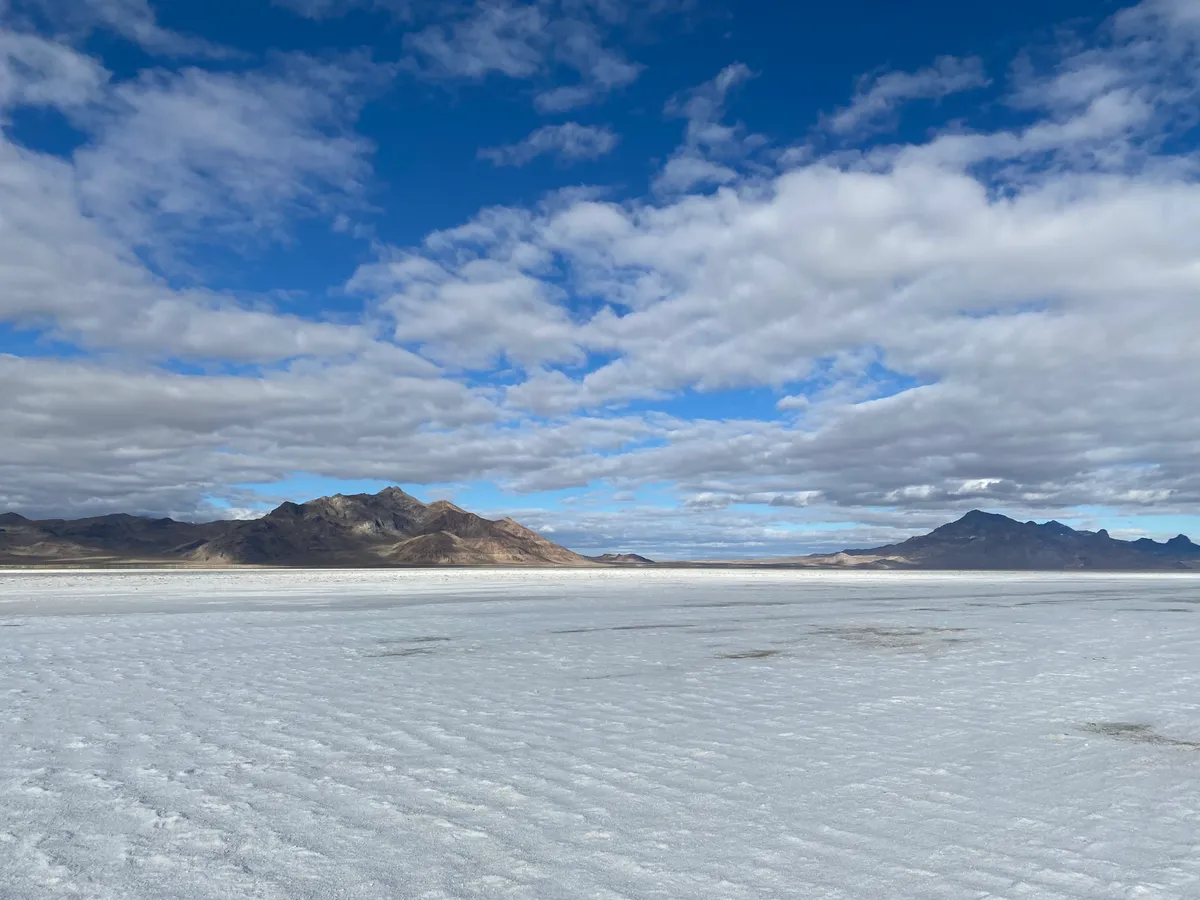
The Bonneville Salt Flats are the remnants of Pleistocene Lake Bonneville in Utah, and they are a tightly packed salt pan located west of the Great Salt Lake.
This terrain is wide open and highly flat, making it an ideal natural location for the Bonneville Speedway. Every year, five major land speed events take place at The Bonneville Salt Flats, drawing thousands of spectators.
This arid desert is an adrenaline oasis, attracting racers and fans from all over the world to enjoy the natural speedway. Several land speed records have been set over the years, and there will undoubtedly be more as long as natural tracks exist. The location has 2 to 3 tracks set up each year depending on the condition of the salt, and it hosts Speed Week in August, World of Speed in September, and the World Finals in October. These events are open to vehicles, trucks, and motorbikes, with some events limited to one or the other. Admission to the raceway varies based on the event, and visitors must carry their own supplies and pack them away upon departure.
The Bonneville Salt Flats are also stunningly picturesque and a popular filming location for advertisements, movies, and television shows. Documentaries and videos on the terrain and the races are readily available, and they all highlight the austere grandeur of the land. The salt flats are well-maintained and open to the public throughout the year.
Fantasy Canyon
Sandstone rock formations that appear to belong on the cover of a progressive rock record.
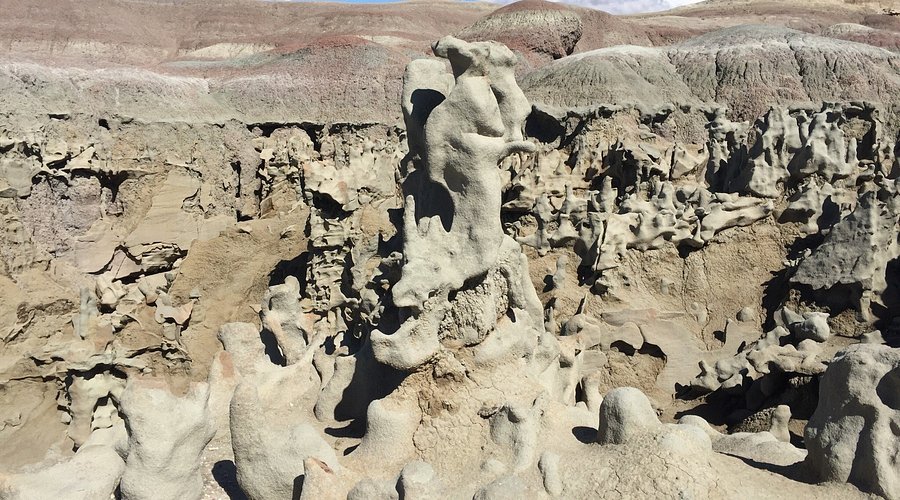
Northeastern Utah has rich of fascinating rock formations formed by a combination of erosion and porous stone, but none are nearly as strange as Fantasy Canyon.
Fantasy Canyon, is home to a variety of odd rock formations. While not as extensive as some of the other desert sites in the state, Fantasy Canyon’s smooth, undulating ridges and loops appear to have been imported directly from a science-fiction film.
The formations are the result of ancient rivers and lakes that once flooded the area, depositing layers of sand and mud that cemented into rock before being carved into fantastical designs by the weather. Visitors can take a short stroll into the canyon and rest on the single round bench. It’s nearly like taking a nap on the surface of Mars.
Goblin Valley State Park
Bizarre lunar-like landscape with thousands of large stone “hoodoos.”

The arid, sandy topography of Goblin Valley is overflowing with naturally artistic, odd rock formations that provide an elaborate display of geological history.
Visitors are welcome to explore the maze of rock creatures and experience the goblins’ strange, frightening emotions. Goblin Valley’s hoodoos are mushroom-shaped sandstone boulders that reach heights of up to 50 feet. Hoodoos are often found in arid, rocky environments. Their form results from the sandstone’s inconsistent hardness. The top of the stone is often tougher than the bottom, shielding the foundation from elemental deterioration. Wind and water eroded these massive sandstone rocks over time. The end effect is an army of distinct hoodoo goblins.
Animals and plants are sparse in Goblin Valley due to a scarcity of water and food. However, the rocks, coves, and hundreds of miles of gravel roads will awe and entertain any tourist.